
 41.750° N, 16.148° E


Complete guide
Baia dei Mergoli or delle Zagare: beach guide
What the beach is like
The Baia delle Zagare, also known as the Baia dei Mergoli, is a stretch of coast in the municipality of Mattinata, on the Gargano, in Puglia. The bay lies between Mattinata and Vieste, in the province of Foggia. The centre of Mattinata is 9.2 km to the south-west as the crow flies, and the centre of Vieste is 15 km to the north.
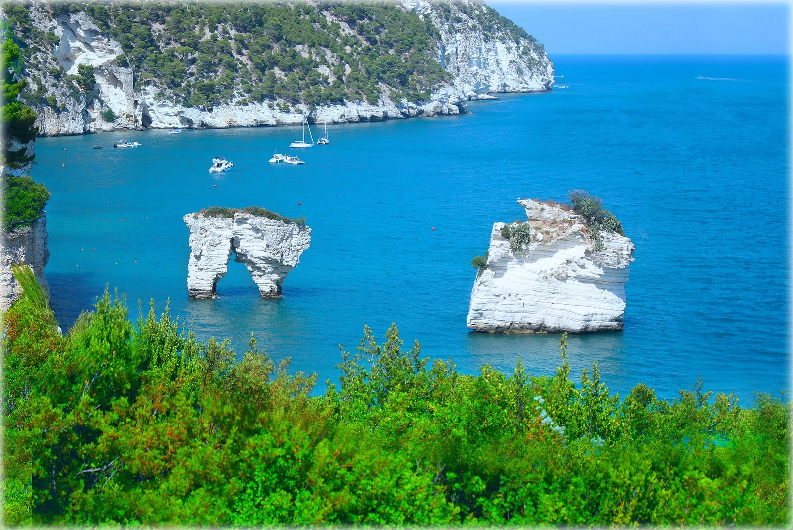
The name comes from the zagare, the blossoms of citrus trees, and from the blackbirds and blue rock thrushes found in the area. The bay opens in front of a limestone cliff. A few metres from the shore, two sea stacks rise from the water, the Arco di Diomede and Le Forbici. Locals say that swimming through the Arco di Diomede brings good luck. The bay also has a cave known as the grotta delle finestre.
According to Wikipedia, the bay is divided into three beaches separated by rocky outcrops: the two longest measure 260 m and 450 m, while the third, the northernmost, is 60 m long and can only be reached by sea. Italia.it describes two beaches that are not connected, about 1 kilometre long in total and separated by a large spur of rock. The first, towards Vieste, is sand and gravel. The second, towards Mattinata, is the Mergoli beach proper, with a shore of smooth white stones. Counting the small Cala dei Morti as well, the northernmost, made of gravel and reachable only from the sea, there are three beaches. According to QualeSpiaggia data, the beach is made of pebbles.
Getting there
According to Italia.it, access is the bay's only sore point. The beach is almost entirely taken up by bathing facilities run by the hotels that stand above it. The same portal states that access is allowed to hotel guests, who go down by a lift carved into the rock, and to holders of a limited number of non-transferable passes, handed out every day by the Comune's public relations office and by the municipal police headquarters in Mattinata. Another Italia.it page refers to a special paid pass, while Wikipedia writes that the southernmost beach is free once a daily access permit has been obtained from the Comune di Mattinata. Before setting off, it is worth checking the access arrangements currently in force.
Again according to Italia.it, only at the hotels is it possible to park for a fee, book sunloungers and umbrellas and take a steep flight of 100 steps down to the beach, where there is a small bar. The page of the Gargano National Park authority, updated on 23 May 2023, states that the beach can be reached by sea or over land through the hotel of the same name, with a lift built into the rock.
The bay is also a stop on boat trips leaving from Vieste or Mattinata. Over land there are old paths that lead down to the sea from the Litoranea SP53. Before walking them it is worth asking local operators for information, so as not to end up on routes that are poorly marked, in bad condition or closed.
To reach Mattinata, the reference airport is Bari and, by train, the station is Foggia. From Foggia there is a direct Ferrovie del Gargano bus service that runs via Manfredonia.
When to go
It is best to arrive in the morning, because in the afternoon the sun soon disappears behind the high cliff and leaves the beach in shade. The name recalls the citrus blossom, which comes in spring and in autumn.
According to QualeSpiaggia data, the beach faces south-east. It is therefore exposed to the east wind (levante), the sirocco (scirocco) and the south wind (ostro), which come in from the sea and can bring waves. With the north wind (tramontana), the west wind (ponente) and the mistral (maestrale), which blow from the land, it is sheltered and the sea close to shore tends to be calmer. The north-east wind (grecale) and the south-west wind (libeccio) hit it from the side. This is an indication based on orientation, not a forecast.
Seabed and sea
The bay looks out over the Adriatic Sea. In the 2025 season the European Environment Agency (EEA) rated the bathing water quality at the monitoring point associated with the beach as excellent. The bay has been awarded Legambiente's 3 Vele. Fins, mask and snorkel are useful for getting close to the sea stacks.
The cliffs and sea stacks are made of deformed limestone and siliceous layers, called slumpings, formed by underwater landslides during sedimentation. These rocks belong to the Maiolica formation, from the Lower Cretaceous, made of white limestone in thin layers with bands and nodules of chert.
Rules and protected areas
The whole stretch of coast that includes the bay is part of the Gargano National Park, about 120,000 hectares. According to the page of the Gargano National Park authority, the beach's sunloungers and umbrellas are for the exclusive use of hotel guests.
Nearby
The Mergoli-Vignanotica path, also called the Sentiero dell'Amore, is a well-marked panoramic route of about 3 kilometres that takes less than an hour and starts from the Litoranea SP53. The path runs through almond trees, Aleppo pines and olive groves, and along its first stretch offers a view over the whole bay. At a fork, keeping right, it goes down to the beach of Vignanotica, equipped in summer with facilities and refreshment points.
Vignanotica lies 1.9 km to the north-east of the bay as the crow flies. Italia.it describes it as 500 metres of sand mixed with gravel with a steep cliff behind it. The park authority, which describes it as a beach of white pebbles, specifies that it lies half in the municipality of Vieste and half in that of Mattinata.
Sources
- Wikipedia (it) — Baia delle Zagare
- QualeSpiaggia — open data spiagge (CC BY 4.0)
- Baia delle Zagare: spiagge nel Gargano a Mattinata - Italia.it
- OpenStreetMap
- Spiaggia di Mattinata, nel cuore del Gargano - Italia.it
- Baia delle Zagare – Ente parco nazionale del Gargano
- Wikivoyage (en) — Mattinata
- EEA — Bathing water quality 2025 (IT016071031001)
- Baia di Vignanotica e Baia delle Zagare – Ente parco nazionale del Gargano
- Mattinata – Ente parco nazionale del Gargano