
 41.181° N, 9.476° E


Complete guide
Spiaggia del Relitto: beach guide
What the beach is like
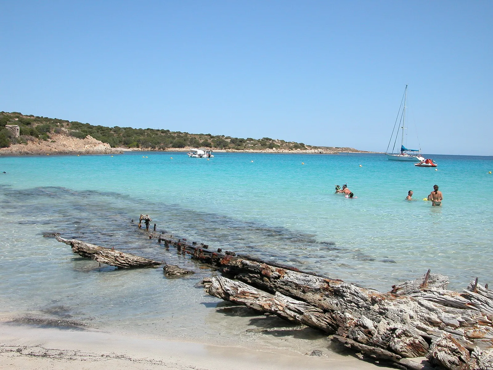
Spiaggia del Relitto lies in the municipality of La Maddalena, in Sardinia, on the Tyrrhenian Sea. It occupies an eastern stretch of coast on the Punta Rossa headland, in the south-eastern part of Caprera, the second-largest island of the La Maddalena Archipelago National Park. The beach is arc-shaped and set in a bay surrounded by dense Mediterranean vegetation. The sand is white and very fine, and the surrounding landscape is wild, enclosed by rugged rocky cliffs. The national park describes it as one of the best-known beaches on Caprera.
On one side of the beach, on the shore, lies the skeleton of a motor sailer that ran aground in 1955. The wreck has been on the beach since the afternoon of 22 June 1955, when a fire broke out on board the motor sailer Trebbo. The ship was carrying coal, had come from Savona and was bound for Cagliari. As the fire could not be put out, it was decided to run the vessel aground at the safest point, west of the isola della Pecora.
Spiaggia del Relitto appears, together with Cala Garibaldi and the Due Mari, on the 2026 Blue Flag list for the island of Caprera. According to the park, the beach is equipped for access by people with reduced mobility.
Getting there
The beach lies 6.8 km as the crow flies south-east of La Maddalena. From Palau you take the ferry to La Maddalena, which is linked to Caprera by the Passo della Moneta, a causeway bridge about 600 metres long. The bridge was built in 1958.
By car you cross the bridge and follow the coast of Caprera southwards. After passing the hamlet of Stagnali, the only inhabited centre on the island, you cross the isthmus leading to the Punta Rossa headland. You continue eastwards along a scenic dirt road through the scrub to a car park: from there it is about 250 metres to the beach. The last stretch, beyond Punta Rossa, is on foot. In the so-called TA zone, the circulation of motor vehicles on paths, beaches and dirt roads is regulated by a 2010 park ordinance.
When to go
Judging from the orientation of the coast, the beach faces south-east. With the levante, scirocco and ostro winds the wind comes from the sea and the beach is exposed to waves and rough sea. With the tramontana, ponente and maestrale the wind blows from the land and the beach is sheltered, with calmer water close to shore. The grecale and libeccio, on the other hand, blow across the shoreline. This is an indication based on orientation, not a weather forecast.
The park reports heavy tourist pressure on the archipelago's waters, with up to 6,000 boats a day. For this reason the park authority has adopted protection rules over the years and, since 2007, specific ordinances against the effects of tourist flows.
Seabed and sea
The sea is clear, with a sandy seabed that is shallow close to the shoreline and then slopes gently out to sea. The colours of the water range from emerald green to blue and turquoise. In the 2025 season the European Environment Agency rated the bathing water quality of this stretch as excellent.
According to the park, the clarity of the archipelago's waters is generally due to Posidonia oceanica, a marine plant that traps suspended sediment, absorbs carbon dioxide, produces oxygen and provides food and shelter for about 25% of Mediterranean species. Since 2024 a park ordinance has been in force with provisions to protect posidonia habitats and seabeds.
Rules and protected areas
The isola della Pecora stands opposite the beach. The stretch of sea between the beach and the islet lies within the park's strict reserve zone and is therefore closed to navigation, mooring, fishing and scuba diving. For Spiaggia del Relitto the park has also issued a specific protection ordinance, no. 2 of 2009, which is listed among the ordinances in force.
Caprera is a fully protected island: it became a nature reserve in 1982 and was later included in the national park. In zone A, under strict protection, fishing is prohibited, as is the case in the marine area between punta Rossa and isola Pecora. The La Maddalena Archipelago Park is Sardinia's first national park, established by the law of 4 January 1994. It includes all the islands and islets of the municipality of La Maddalena and the surrounding marine areas, covering over 180 km of coastline. The protection measures of the decree of 17 May 1996 divide the territory into zones, each with its own prohibitions. The park also publishes an information map of the beaches explaining what is and is not allowed. Anyone entering by boat the 300-metre belt of the park's marine area must pay an entrance fee, regulated by resolution no. 21 of 14.06.2017 of the park authority's extraordinary commissioner.
Nearby
1 km as the crow flies to the west is Cala Portese, more commonly called the Due Mari because the sea washes it on two sides. On the right side there is a small beach of amber sand, on the left a large beach of very white sand. The Due Mari also appear on the 2026 Blue Flag list. From the Cala Portese car park a walk leads to Cala Andreani, in the south of the island, with very fine sand and pinkish rocks rising from the water.
The hamlet of Stagnali, a former military post, houses the park authority's environmental education centre, the museum of the sea and maritime traditions, the mineralogical and natural history museum and the dolphin research centre. The mineralogical museum also displays the different types of sand from Caprera's beaches. Caprera is also known as the last residence of Giuseppe Garibaldi, whose memorabilia are kept in the Compendio Garibaldino.
Sources
- QualeSpiaggia — open data spiagge (CC BY 4.0)
- Spiaggia del Relitto | SardegnaTurismo - Sito ufficiale del turismo della Regione Sardegna
- Caprera - Lamaddalenapark.it
- FEE Italia — Bandiera Blu 2026, elenco spiagge
- Caprera | SardegnaTurismo - Sito ufficiale del turismo della Regione Sardegna
- Stagnali | SardegnaTurismo - Sito ufficiale del turismo della Regione Sardegna
- Misure e norme di salvaguardia dell'Arcipelago di La Maddalena
- EEA — Bathing water quality 2025 (IT020104012010)
- Primo Parco Nazionale della Sardegna
- Mappe - Lamaddalenapark.it