
 40.479° N, 9.810° E


Complete guide
Bérchida beach: beach guide
What the beach is like
Bérchida is a beach on the east coast of Sardinia, within the municipality of Siniscola, in the province of Nuoro. Berchida is a locality south of Siniscola, in the historical region of the Baronie, known above all for its beach. The town of Siniscola lies 14.3 km as the crow flies north-west of the beach.
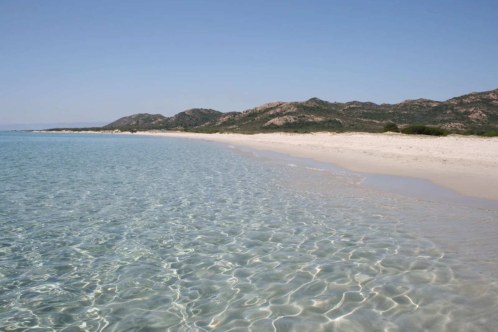
Bérchida is a half-moon five kilometres long of dunes of white sand, covered with centuries-old junipers that form curious natural huts. The beach is long and spacious, with fine sand, shallow water and sea colours ranging from green to turquoise. The tourism portal of the Sardinia Region, SardegnaTurismo, reports that the beach is considered, and has been voted, one of the most beautiful in the Mediterranean.
The beach acts as a barrier to the rio Berchida, creating the pond of the same name. The pond is home to many animal species, some of them fairly rare. The beach is surrounded by centuries-old junipers and Mediterranean scrub. According to Wikipedia, in the surrounding hills there are two forestry sites of the Ente foreste della Sardegna, working to reforest the land after the fires that in the past devastated the forest that once stood there.
The pond is also a watering place for the herds of cattle and sheep that graze in the area. These herds visit the beach in the colder months.
Getting there
The beach can be reached by following the Strada Statale 125 towards Siniscola and then the signs for the beaches. There is a large car park.
Berchida is listed among the frazioni (hamlets) of the municipality of Siniscola. For Siniscola, the reference airport is Olbia-Costa Smeralda. By car, the SS 125 Orientale Sarda runs through Siniscola on the stretch between Orosei and Posada, while from the SS 131 d.c.n. Abbasanta-Nuoro-Olbia the exits given are 2, Siniscola-Lodè-SP45 and Siniscola-Orosei. By bus, according to Wikivoyage, the ARST 514 Olbia-Nuoro line stops in Siniscola.
When to go
SardegnaTurismo presents Bérchida as a secluded and quiet place even in the busiest months. According to QualeSpiaggia data, the beach faces east. Because of this orientation it is exposed to the grecale (north-east wind), the levante (east wind) and the sirocco (scirocco), which come in from the sea and can bring waves. With the libeccio (south-west wind), the ponente (west wind) and the mistral (maestrale), which blow from the land, it is sheltered instead and the sea close to shore tends to be calmer. The tramontana (north wind) and the ostro (south wind) blow across it. This is an indication based on the orientation of the coast, not a forecast.
Before setting off, it is worth checking the wind forecast.
Seabed and sea
The beach faces the Tyrrhenian Sea. In the 2025 season the European Environment Agency (EEA) rated the bathing water quality at the monitoring point associated with the beach as excellent. Wikipedia also reports that the beach is characterised by low or absent values of the main pollutants assessed for sea purity.
The water is shallow and the sea has colours ranging from green to turquoise. At Capo Comino the water is shallow from the shore for tens of metres. When the sea is rough, it is best to stay within your depth.
Facilities and free beach
Among the facilities there are a kiosk-bar, beach equipment, canoe and pedalo hire and a large car park. It is worth bringing water and sun protection.
Nearby
In the valley behind the beach there are two settlements from the Nuragic age: the single-tower nuraghe Conca Umosa and the nuraghe Paule 'e Luca. In the same valley are the remains of the medieval village of Rempellos.
Walking north along the shoreline, you reach the dunes of Capo Comino and s'Ena 'e sa Chitta. This is three kilometres of white sand closed off by rocks near an old lighthouse, off which lies the small Isola Rossa. The seabed off Capo Comino, further out, holds the remains of a Roman fleet from the time of Nero, the ship Comandante Bafile sunk in 1942 and a small French fighter plane that went down in June 1963.
Further north still are the fishing village of Santa Lucia, which grew up around an Aragonese tower, and the resort of La Caletta, with a beach five kilometres long.
South of Bérchida is the Oasi di Biderosa, which lies in the municipality of Orosei. According to SardegnaTurismo, the oasis is a park largely of woodland and Mediterranean scrub, protected by the Ente Foreste and entrusted to the Comune di Orosei, with five coves whose northern boundary is the Bèrchida beach itself. For the oasis, SardegnaTurismo states that access by car and motorbike is limited from May to the end of October, while by bike or on foot there is no seasonal limit but a set of rules must be followed. Italia.it confirms that access to the oasis is regulated from May to October and that it can always be visited on foot or by bike. Before going, it is worth checking the rules in force for the season.
Cala Ginepro beach lies 4.4 km as the crow flies to the south-west, in the municipality of Orosei. The town of Orosei lies 14.8 km as the crow flies south-west of the beach.
Sources
- Wikipedia (it) — Berchida
- QualeSpiaggia — open data spiagge (CC BY 4.0)
- OpenStreetMap
- Berchida | SardegnaTurismo - Sito ufficiale del turismo della Regione Sardegna
- Wikivoyage (it) — Siniscola
- EEA — Bathing water quality 2025 (IT020091085008)
- Capo Comino | SardegnaTurismo - Sito ufficiale del turismo della Regione Sardegna
- Oasi di Bidderosa | SardegnaTurismo - Sito ufficiale del turismo della Regione Sardegna
- Oasi di Biderosa - Italia.it