
 39.117° N, 9.521° E


Complete guide
Porto Giunco: beach guide
What the beach is like
Porto Giunco is a beach in the municipality of Villasimius, in south-eastern Sardinia. The tourism portal of the Sardinia Region lists it as one of the island's best-known beaches and one of the most beautiful in Italy, according to TripAdvisor users and some specialist magazines. Film directors and advertisers have chosen it as the setting for their commercials.
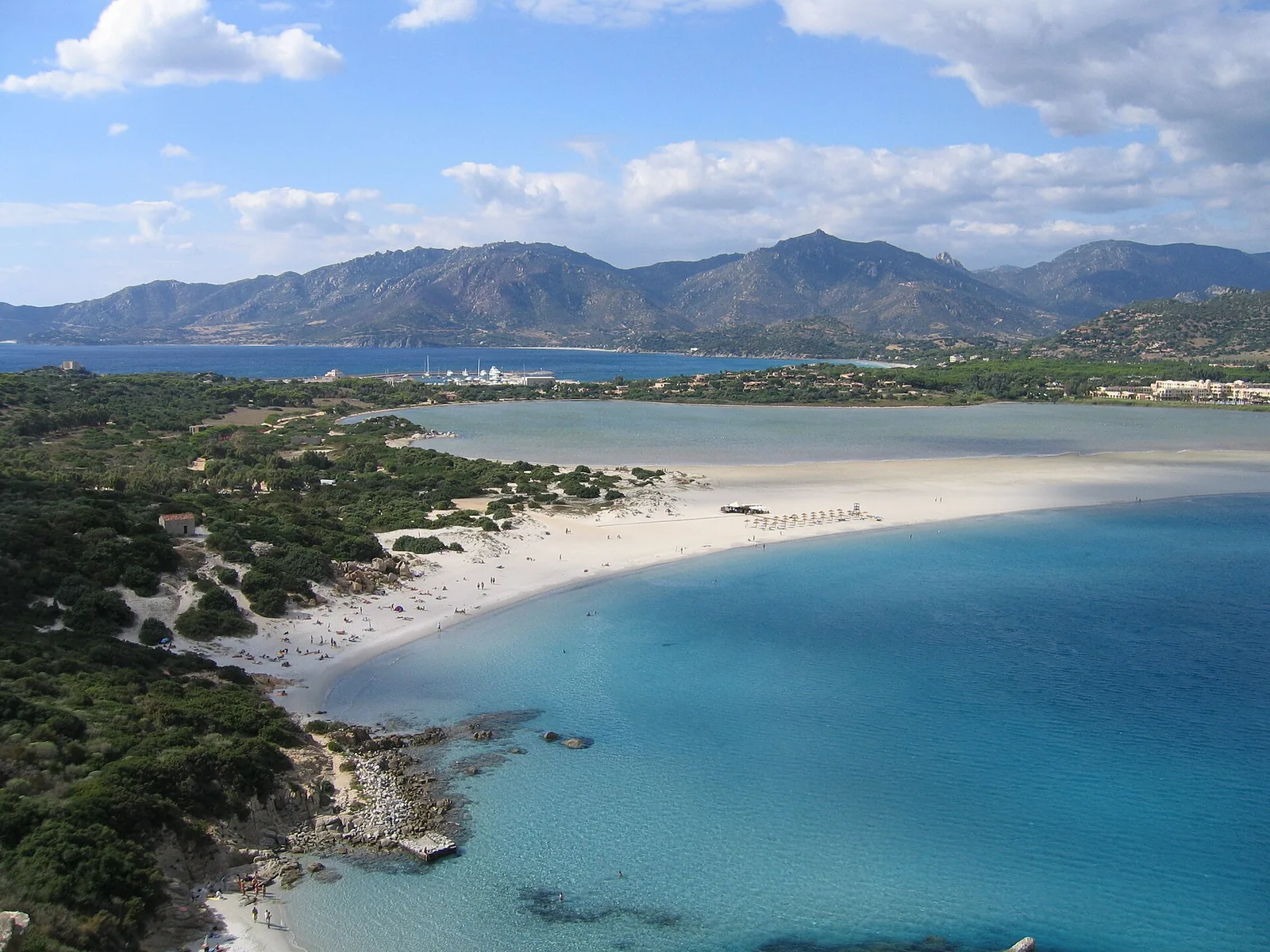
The beach is a long stretch of soft, very pale sand, with pink hues that come from fragments of granite. It is a tongue of sand separating two bodies of water: the sea in front and the Notteri lagoon (stagno di Notteri) behind. This is why it is also nicknamed the beach of the two seas. The lagoon was once rich in rush beds (giunco), which gave the beach its name. The same strip of sand is also called Notteri beach, after the lagoon. The lagoon has no outlets or connections to the sea and is half a metre deep. Along the south-eastern coast, pink flamingos can be seen only here and in the Colostrai and Feraxi lagoons.
The surrounding dunes are covered with junipers, mastic trees and Mediterranean scrub. The beach is large enough to leave plenty of room to lie down.
On a headland, guarding the bay, stands the Porto Giunco tower, nine metres high. The tower dates from the seventeenth century and was built by the Spanish. Together with the Fortezza Vecchia and the Capo Boi tower, it was part of a coastal watch system against pirate raids. Hikers can climb the headland up to the tower.
Getting there
The beach can be reached in a few minutes from the town centre, heading towards the marina. The Region's road directions start from via Cagliari, provincial road 17, and continue along via delle Aquile, via degli Oleandri and via dei Ginepri. The village of Villasimius lies 2.9 km as the crow flies north of the beach.
From the large car park, a footpath crosses a small eucalyptus grove and leads to the beach. The path runs alongside the Notteri lagoon, chosen as a habitat by pink flamingos and other migratory birds. If you are walking, it is worth bringing water and a sun hat.
When to go
Based on the orientation of the coast, QualeSpiaggia data show that the beach faces south-east, onto the Tyrrhenian Sea. With the east wind (levante), the sirocco (scirocco) and the south wind (ostro), the wind blows in from the sea and the beach is exposed to waves. With the north wind (tramontana), the west wind (ponente) and the mistral (maestrale), the wind blows from the land and the sea near the shore tends to be calmer. The north-easterly (grecale) and the south-westerly (libeccio) strike it from the side. This is an indication derived from the orientation of the coast, not a forecast.
Seabed and sea
The seabed is sandy and very shallow. The sea has a soft light-blue tone that takes on many shades further offshore. In the 2025 season the water at Porto Giunco was rated excellent by the European Environment Agency.
For snorkellers and divers, the regional page mentions shoals of tame fish following the warm currents. The same page also lists it as a destination for surfers. The seabed of the marine protected area has granite pinnacles and crevices coloured by the yellow of sea daisies and the red of gorgonians. The area's managing body reports groupers, dentex, gilthead bream and schools of Mediterranean barracuda, as well as the frequent presence of the bottlenose dolphin, the coastal dolphin.
On the beaches of Villasimius, Posidonia oceanica washed ashore forms heaps called banquettes. These heaps help regulate the distribution of sand between the emerged and the submerged beach.
Facilities and free beach
The beach has bathing and rental services, with hotels and residences around it. Along the shore there are kiosk bars and night venues. The regional page on the lagoon describes the beach as dotted with refreshment points and beach establishments. The regional portal describes the beach lit with torches at sunset and the kiosks with aperitifs and music.
Rules and protected areas
Porto Giunco is part of the Capo Carbonara marine protected area. The area was established by a 1998 decree of the Ministry of the Environment, amended in 1999 and entirely replaced in 2012. It is divided into four zones with different levels of protection: A, full reserve; B, general reserve; C, partial reserve; and D, experimental reserve. The boundaries of the A zones are marked by buoys at sea and posts on land, coloured yellow, with a night-time flashing light.
According to the managing body, swimming, fishing and the passage of unauthorised boats are prohibited in zone A. In zones B and C navigation is allowed at low speed, no more than 10 knots. In zones B, C and D spearfishing, jet skis and water skiing are prohibited. Anyone arriving by boat should check beforehand which zone they intend to stop in.
With children
Because the seabed is very shallow and sandy, the regional portal considers it suitable for families with children. Still, keep an eye on children in the water and protect them from the sun.
Nearby
Spiaggia del Riso lies 1 km as the crow flies to the west and stands out for its grains of sand that look like grains of rice. Fortezza Vecchia, 1.3 km to the west, is a small crescent-shaped beach below the Spanish fortress of 1572. Cala Caterina beach, 1.5 km to the south-west, consists of two secluded inlets surrounded by granite rocks.
Campulongu beach, 1.7 km to the north-west, is an arc of pale, fine sand 1 km long. Punta Molentis, 3.6 km to the north-east, is an inlet with a distinctive arched shape.
Sources
- OpenStreetMap
- EEA — Bathing water quality 2025 (IT020092100004)
- QualeSpiaggia — open data spiagge (CC BY 4.0)
- Porto Giunco | SardegnaTurismo - Sito ufficiale del turismo della Regione Sardegna
- Stagno di Notteri | SardegnaTurismo - Sito ufficiale del turismo della Regione Sardegna
- Spiagge a Villasimius - Area Marina Protetta
- Zone - Area Marina Protetta
- Attività consentite - Area Marina Protetta
- La Storia - Area Marina Protetta