
 41.279° N, 9.356° E


Complete guide
Spiaggia Rosa, Budelli: beach guide
What the beach is like
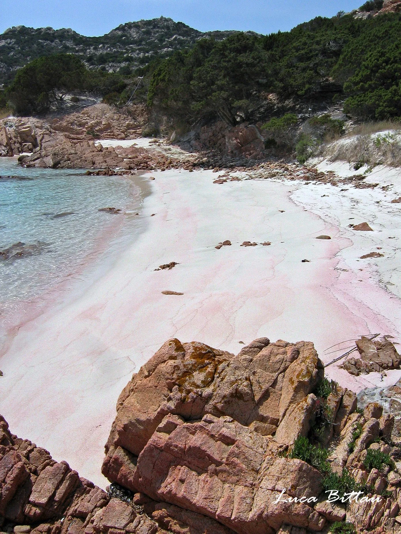
Spiaggia Rosa lies at Cala di Roto, on the south-eastern side of the island of Budelli, in the La Maddalena archipelago, according to Wikipedia. It sits in a wide inlet, sheltered on its northern side by a small, very jagged rocky headland and on the opposite side by a much higher headland. Behind it, a belt of juniper protects it from the westerly winds.
The name comes from the pink colour of the dry sand, due to the calcareous shells of Miniacina miniacea, a foraminifer that lives on organic substrates such as the rhizomes of Posidonia oceanica. The sand also contains fragments of bryozoan skeletons, in particular Miriapora truncata. In both the dry and the submerged sand, the share of skeletons of marine micro-organisms, white and pink, reaches 80–90%. The sand is rich in tiny fragments of coral, granite, shells and mollusc shells. When the pink micro-organism dies, the shells are washed ashore and broken up by water and wind.
In the twentieth century, anchoring and irregular sea movement pushed back the posidonia and changed the composition of the sand. Besides unwitting removal by visitors, the sand was also the target of theft, which is why the area was made a protected area. Since full protection rules were introduced, the beach has regained its original colour. In 1964 Michelangelo Antonioni shot parts of the film Deserto rosso here, his first film in colour.
Getting there
Budelli can only be reached by sea. Delcomar and Maddalena Lines ferries link Palau with La Maddalena in about 15 minutes. Many boat services leave from Palau and La Maddalena for tours of the archipelago, which let visitors see the beach from the sea. The park's website publishes the 2026 list of the companies authorised to carry passengers and of their routes.
On the same page as the 2026 list, the park states that certain activities within it require an authorisation, the ticket, which allows sailing, mooring, anchoring and stopping within the 300-metre coastal strip under the established rules. The park's website warns that entering park waters without authorisation exposes visitors to fines and a 40% surcharge imposed by inspection staff. Kayaks, pattini, pedalos and windsurf boards are exempt from payment.
Wikipedia places the beach at Cala di Roto, while the regional tourism portal names Cala di Roto, together with the spiaggia del Cavaliere, as a point from which to view it on land, accompanied by national park guides. The park has built a path of wooden boardwalks around the perimeter of the beach, so that it can be viewed without being walked on.
When to go
The beach faces south-east. With the tramontana, the westerly (ponente) and the mistral (maestrale), the wind blows from land and the bay is sheltered. With the easterly (levante), the scirocco and the southerly (ostro), the wind blows from the sea and the beach is exposed. The north-easterly (grecale) and the south-westerly (libeccio) hit it from the side. This is an indication based on the orientation of the coast, not a forecast.
The archipelago has windy, relatively cold winters and hot summers. In spring, orchids of the genera Orchis, Ophrys and Serapias flower in the island's small clearings.
Seabed and sea
The concentration of bioclasts depends partly on the shape of the seabed and coast, an extensive meadow of Posidonia oceanica and low-energy currents. Wikipedia calls Posidonia oceanica the most important marine seagrass in the Mediterranean. The archipelago's waters are home to dolphins, sperm whales and rorquals. In the stretch of sea separating Budelli from Spargi lies the Washington shoal, made of granite blocks coloured red by gorgonians.
For this beach, where swimming is prohibited, QualeSpiaggia has no EEA water quality classification.
Rules and protected areas
The beach lies within Zone A, the full-protection zone, of the La Maddalena Archipelago National Park. Access, transit, stopping and swimming are prohibited. Wikipedia dates the ban to 1994, the year the park was established, while the regional tourism portal dates the full protection rules to 1998.
The sources do not agree on the waters in front of the beach. The national park's page on the island states that swimming, sailing, anchoring and stopping boats are prohibited in the strip of sea in front of the beach. Wikipedia and the italia.it portal, by contrast, say that boats may sail up to the buoys that close off the bay, about 70 metres out from the shore, at slow speed according to Wikipedia. Before approaching, it is wise to check the current rules with the park.
The park council decided to install, together with the WWF, surveillance cameras for constant monitoring of the beach. Budelli had been privately owned since the last century and became public property in 2016, when it was assigned to the park.
Nearby
Budelli is the sixth-largest island in the archipelago, with an area of about 1.70 sq km and a perimeter of about 9 km. Together with Razzoli and Santa Maria it encloses the stretch of water known as I Passi, made up of the Passo del Topo and the Passo degli Asinelli. From the caretaker's house, a path climbs through the Mediterranean scrub to monte Budello, the island's highest point at 88 metres. From the top you can see La Maddalena and the Strait of Bonifacio (Bocche di Bonifacio).
The spiaggia del Cavaliere, on the north-eastern side of Budelli, overlooks the Porto della Madonna, the stretch of water enclosed by Budelli, Razzoli and Santa Maria. It has very fine white sand and a shallow sandy seabed suitable for families with children. Because of erosion of the beach, documented by scientific studies, it has been only partly open since the summer of 2020.
The nearest beach is Spiaggia di Cavalieri, 0.8 km to the north as the crow flies. The archipelago's only town is La Maddalena, on the island of the same name. In 2026, the La Maddalena beaches on the FEE's Blue Flag (Bandiera Blu) list include Bassa Trinità, Monte d'a Rena, Spalmatore and Tegge. On Caprera you can visit the Compendio Garibaldino, with Garibaldi's tomb and house.
Sources
- Wikipedia (it) — Spiaggia rosa
- Wikipedia (it) — La Maddalena (comune)
- Wikivoyage (en) — Maddalena archipelago
- FEE Italia — Bandiera Blu 2026, elenco spiagge
- OpenStreetMap
- QualeSpiaggia — open data spiagge (CC BY 4.0)
- Spiaggia Rosa | SardegnaTurismo - Sito ufficiale del turismo della Regione Sardegna
- La spiaggia rosa dell'Isola di Budelli, Sardegna - Italia.it
- Budelli - Lamaddalenapark.it
- autorizzazioni