
 40.108° N, 9.690° E


Complete guide
Cala Goloritzé: beach guide
What the beach is like
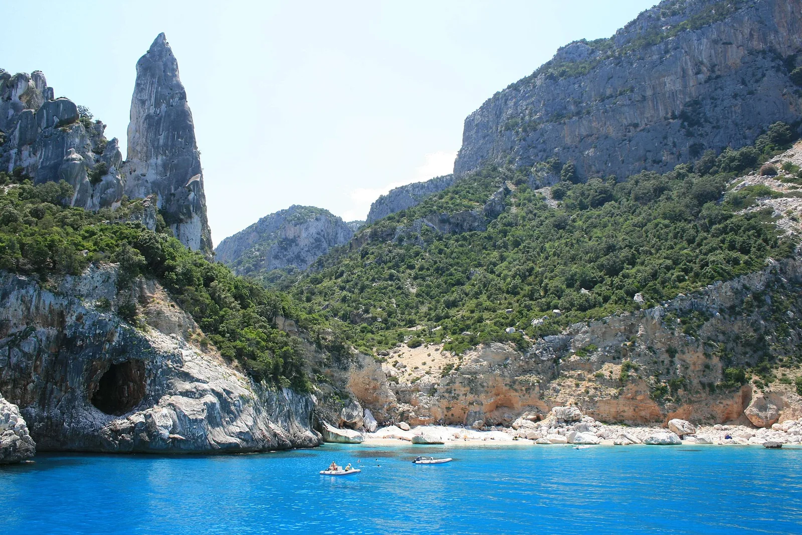
Cala Goloritzé lies within the municipality of Baunei, in the southern part of the Gulf of Orosei (golfo di Orosei). The cove lies north of Capo Monte Santo. Along this stretch, the rocky coastline, which until here drops sheer into the sea, recedes inland and forms an inlet covered with smooth white pebbles. The beach is made up of small white pebbles and sand. It formed in 1962, after a landslide broke away from the sandstone cliff.
Above the cove rises a 143-metre pinnacle, the pyramid-shaped limestone spire of monte Caroddi. It is also called the aguglia a tramontana, so as not to confuse it with Perda Longa di Baunei. On the right-hand side of the bay a natural arch opens up, carved by the sea into the rock wall that closes the bay on its southern side. Among the rocks of the beach there is a freshwater spring that flows from underground into the sea. All around rise 500-metre cliffs covered in Mediterranean scrub and, behind, a forest of holm oaks and strawberry trees.
On 29 April 2025 the website The World's 50 Best Beaches put it in first place in its world ranking. The spire is well known to climbers: the most famous route is the Sinfonia dei Mulini a vento, opened by Maurizio Zanolla, known as Manolo, and Alessandro Gogna. According to the regional tourism portal, after their ascent in 1981 the beach became a destination for free climbing enthusiasts; Wikipedia, however, dates the opening of the route to the late seventies. The area is also a nesting habitat for Eleonora's falcon (falco della regina).
Getting there
By land, the cove can only be reached on a path that descends from the Golgo plateau. The walk starts from the su Porteddu car park and crosses the Supramonte di Baunei with a height difference of 470 metres. The regional tourism portal gives a path of about 3 kilometres in one place and a route of three and a half kilometres in another. The same portal estimates about an hour going down and an hour and a half climbing back up, while Wikipedia mentions about an hour and a half of walking. Less experienced walkers should turn to a local guide. Everyone, given how wild the place is, needs suitable clothing and plenty of water.
According to the italia.it page on the 2025 ranking, land access is limited and requires an online booking, which can only be made from the third day before the visit. For information the page refers to the turismobaunei.eu website. For 2024, English Wikipedia reports a ticket of 7 euros per person, a maximum of 300 visitors a day and online registration at least one day in advance.
By sea, you can join group charters or hire a dinghy in the ports of Arbatax, Cala Gonone and Santa Maria Navarrese, but landing in the cove is not allowed. Santa Maria Navarrese, a hamlet of Baunei, is 13.2 km south of the beach as the crow flies. The village of Baunei is 8.7 km to the south as the crow flies. Baunei is crossed by the SS 125 Orientale Sarda road, and the Arst 303 Arbatax-Nuoro bus line stops there. The beach is not accessible to wheelchair users.
When to go
According to QualeSpiaggia data, the cove faces north-east. With the tramontana, the north-easterly (grecale) and the easterly (levante), the wind blows from the sea and the beach is exposed to waves. With the southerly (ostro), the south-westerly (libeccio) and the westerly (ponente), the wind blows from land and the cove is sheltered. The scirocco and the mistral (maestrale) hit it from the side. This is an indication based on the orientation of the coast, not a forecast.
English Wikipedia reports that in peak periods up to 800 people a day would like to visit, against the 300 allowed. In summer it is therefore wise to book ahead and set off in the cooler hours.
Seabed and sea
Water wells up in the cove from underwater karst springs, and time-worn marble rocks rise out of the sea. The springs flow up through the rocks and barely stir the very clear seabed. The beach is estimated at 150 by 30 metres. For this beach, QualeSpiaggia has no EEA water quality classification.
Rules and protected areas
Cala Goloritzé was declared a natural monument by the Regione Sardegna in 1993 and a national monument in 1995. Since the summer of 2007, according to Wikipedia, the stretch of sea closed to motorboats extends 200 metres from the shore, and landing is also prohibited. italia.it also states that boats must anchor about 200 metres away and that from there the cove is reached by swimming. The regional tourism portal instead reports a mooring ban extending 300 metres from the shore, with marker buoys beyond which you continue by swimming or rowing. Before setting off, it is wise to check the current rules on the website indicated by italia.it.
In 2024 the ticket served to protect and clean the beach. The cove is one of the stages of the Selvaggio Blu trek.
Nearby
A little further north-west is the Spiaggia delle Sorgenti, 0.4 km away as the crow flies, named after the spring water that wells up among the rocks. Cala Mariolu, 2 km to the north-west as the crow flies, has pebbles resembling sugared almonds mixed with sand. Its natural continuation is Cala dei Gabbiani. Cala Biriola opens at the end of a wood of centuries-old holm oaks, and just before it, for those arriving by boat, are the piscine di Venere pools. Cala Sisine, 9.2 km to the north-west as the crow flies, lies at the end of a gully that was once a riverbed.
Cala Luna, shared with the municipality of Dorgali, was the set of the film Travolti da un insolito destino. The grotte del Bue marino caves, once a habitat of the monk seal, are in the municipality of Dorgali. Inland lie the Golgo sinkhole, known as Su Sterru, and the church of San Pietro del Golgo, an ancient place of worship first Nuragic and then Christian. On the coast stands Perda Longa, a limestone spire rising sheer from the sea, reachable by car on a paved road that leaves the SS 125 just outside Baunei.