
 40.123° N, 9.677° E


Complete guide
Cala Mariolu: beach guide
What the beach is like
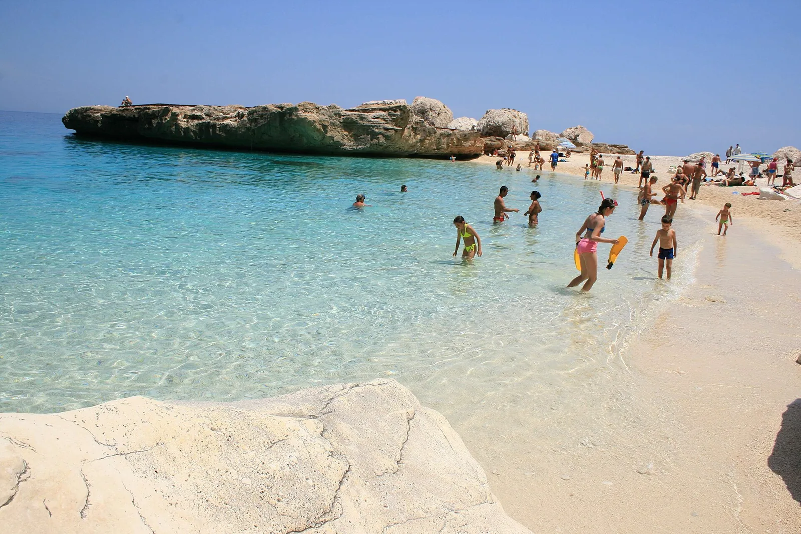
Cala Mariolu lies in the Gulf of Orosei, within the municipality of Baunei, in the province of Ogliastra. Ispuligedenìe is the name of the locality that contains two beaches, Cala Mariolu and the Spiaggia dei Gabbiani. They are separated by what maps mark as punta Ispùligi, called Sa plaigge de curadore in the Baunei dialect. Cala Mariolu is a beach about 300 metres long, lying between the flat rock that marks the edge of Cala dei Gabbiani and the sheer cliff that closes off the Ispuligidenie forest. The tourism website of the municipality of Baunei calls it one of the best-known and busiest beaches on the Baunei coast today. A large rock, used as a landing stage by the boats that carry tourists, divides it into two parts.
The beach is made up of small round pebbles, white and pink, mixed with sand. This is why it is also known as is pùligi de nie, meaning snow fleas. The cliff that surrounds it reaches 500 metres in height and drops sheer into the water on both sides, to the north and to the south. Several caves open up in the surrounding area, one of which is inside the cove. This cave begins with a small beach and reaches back ten metres deep.
The beach has two names. Ispuligidenie is the older one and was used by the Baunei shepherds who frequented the hinterland. It is said to derive from su pulige de nie, a metaphor the shepherds used for the white pebbles smoothed by the waves, and is said to have later come to refer to the whole forest above the beach. There is also another form of the local place name, Ispuligiada 'e nie, meaning a sprinkling of snow. Cala Mariolu, on the other hand, means thief's cove. The name comes from the fishermen from Ponza who settled in Cala Gonone and Arbatax at the beginning of the twentieth century. In their dialect they called the monk seal o mariuolo, the thief; the seal once frequented this stretch of coast and stole fish from the nets. The fishermen from Ponza caught lobsters and carried them, still alive, all the way to Marseille.
Punta Is Puligi once served as a coal loading point for the furisteris, the charcoal burners who settled in Baunei. The charcoal burners worked in the Ispuligidenie forest until 1953.
Getting there
The easiest way to reach the cove is by sea, leaving from Santa Maria Navarrese or Arbatax to the south, or from Cala Gonone to the north. The cove can be reached by private boat or by the cove services departing from the ports of Arbatax, Cala Gonone and Santa Maria Navarrese. A large rock, sa perda 'e su saltatori, serves as a jetty.
On land, the cove can only be reached on a demanding hike, suitable for experienced walkers, through dense Mediterranean scrub. The hike is recommended only for those who are truly experienced. The path crosses the Golgo plateau of Baunei and Serra Lattone and, after the Ispuligi de nie woods, reaches the cove. The Ispuligidenie forest is entered from the Golgo plateau, at the locality of Piredda, following signs placed for hikers, on a demanding route of 3-4 hours' walk. It is not rare for careless hikers to get lost in the Supramonte of Baunei while trying to reach the beaches from inland.
The village of Baunei is 10.2 km south of the beach as the crow flies, Santa Maria Navarrese 14.9 km. Baunei is crossed by the SS 125 Orientale Sarda and Arst bus line 303 Arbatax-Nuoro stops there. The regional tourism portal's page lists access to the cove as free. Before setting out, it is worth checking with the municipality the rules in force for the season.
When to go
According to QualeSpiaggia data, the cove faces north-east. With the north wind (tramontana), the north-east wind (grecale) and the east wind (levante), the wind blows in from the sea and the beach is exposed to the waves. With the south wind (ostro), the south-west wind (libeccio) and the west wind (ponente), the wind blows from the land and the sea close to the shore tends to be calmer. The south-east wind (scirocco) and the north-west wind (maestrale) hit it from the side. This is an indication based on the orientation of the coast, not a forecast.
Anyone choosing the hike should set out with enough water and suitable shoes.
Seabed and sea
The shallow seabed lends itself to a dip with a mask for those less confident in the water, or with diving equipment for those who want to explore it in more depth. It is home to various species. Dolphins can occasionally be glimpsed offshore. The cove is also recommended for swimming and snorkelling. The sea has shades ranging from light blue to emerald green. QualeSpiaggia has no EEA water quality classification for this beach.
Out of the water, visitors can spot the peregrine falcon, Eleonora's falcon, the European shag and the golden eagle.
Nearby
Cala dei Gabbiani is 0.4 km to the south-east as the crow flies. It is about 250 metres long and owes its name to the dozens of gulls that gather there every evening, towards sunset. The large boats that shuttle along the coast do not stop there, so it is not crowded even in high season. Its seabed gets deep straight away and is rocky.
Further south-east are the Spiaggia delle Sorgenti, 1.6 km away as the crow flies, and Cala Goloritzè, 2 km away. To the north-west lie Cala Biriala, 3.4 km away as the crow flies, and Cala Sisine, 7.2 km away. The grotta del Fico is not far away and, along the gulf, lies Cala Luna, shared with the municipality of Dorgali.
Also worth seeing are the Golgo sinkhole, known as Su Sterru, and the church of San Pietro del Golgo, an ancient place of worship, first Nuragic and later Christian. Perda Longa is a limestone spire rising sheer above the sea, which can be reached by car on a paved road branching off the SS125 just outside Baunei.
Sources
- Wikipedia (it) — Cala Mariolu
- Wikivoyage (it) — Baunei
- OpenStreetMap
- QualeSpiaggia — open data spiagge (CC BY 4.0)
- Cala Mariolu | SardegnaTurismo - Sito ufficiale del turismo della Regione Sardegna
- Cala Mariolu - Italia.it
- “Ispuligidenie” – Cala Mariolu - Costa di Baunei
- Cala dei Gabbiani - Sito Ufficiale Turismo Baunei Santa Maria Navarrese Visit Baunei