
 40.598° N, 9.753° E


Complete guide
La Caletta, Siniscola: beach guide
What the beach is like
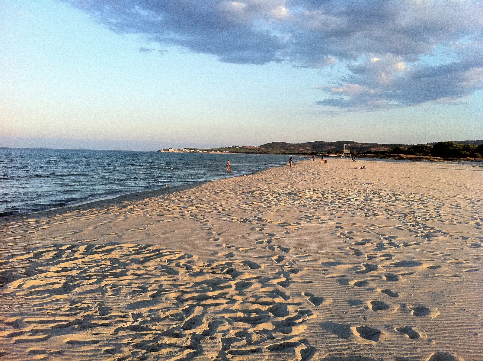
La Caletta beach lies in the municipality of Siniscola, in the province of Nuoro, on the east coast of Sardinia. It is washed by the Tyrrhenian Sea. Sardegna Turismo, the official tourism website of the Regione Sardegna, describes it as a long, wide beach of soft golden sand. It starts from the small seaside village of the same name, a hamlet of Siniscola, and runs as far as the su Graneri lagoon. English Wikipedia, by contrast, says that the beach in front of the village ends at the small town of Santa Lucia.
A pinewood borders the so-called big beach (spiaggia grande), which almost joins the beach of San Giovanni di Posada. The two beaches are separated only by the La Caletta marina. The small bay of the old fishing village was turned into a marina in the seventies, and later renewed and enlarged. The inhabitants of the village work mainly in tourism, trade and fishing. In the nineteenth century the inhabitants called the place Pedras Nieddas, meaning black stones. The French writer André Pieyre de Mandiargues set his 1956 novel Il giglio di mare on La Caletta beach.
Getting there
From the SS 125 Orientale Sarda, on the stretch from Orosei to Siniscola, take the exit for La Caletta. From the SS 131 d.c.n. you can exit towards Siniscola and then take the SP 3 to La Caletta, or exit at Posada-Lodè-Torpè and follow the SP 24 to Posada and San Giovanni di Posada. The ARST 514 Olbia-Nuoro bus line stops at La Caletta. The Deplano company links Olbia airport with La Caletta on a seasonal summer line. La Caletta offers a large car park, a regular stop for campervan travellers and campers.
The village of San Giovanni is 2.4 km as the crow flies north of the beach's reference point. The centre of Siniscola is 5.7 km as the crow flies to the south-west.
When to go
The beach faces east. With the north-easterly grecale, the easterly levante and the south-easterly scirocco the wind comes off the sea and the beach is exposed to waves and rough water. With the south-westerly libeccio, the westerly ponente and the north-westerly maestrale the wind blows from land and the beach is sheltered, with calmer water near the shore. The northerly tramontana and the southerly ostro blow across the shore instead. These indications are derived from the orientation of the coast and are not weather forecasts. The coast is often windswept and the big beach is equipped for kitesurfing and windsurfing.
In the second week of May the feast of the Madonna di Fatima is held for 3 days, together with a fish festival. On 14 August the fishermen escort the image of the Madonna Assunta with their fishing boats for the blessing of the sea. The Rally del Montalbo starts from La Caletta in the first week of September.
Seabed and sea
The seabed is sandy. The sea is blue and the seabed shallow. For the 2025 season the European Environment Agency (EEA) rates the bathing water quality of this stretch as excellent. La Caletta accounts for almost half of the 12 kilometres of sand on the Siniscola coast.
Facilities and free beach
The marina offers sailing, surfing and diving schools, equipment hire and departures for boat and dinghy trips. The village has car and bike hire, restaurants, pizzerias and bars. The area has accommodation for every type of guest. The Coast Guard office is in via Cagliari, and a pharmacy, a parapharmacy and the post office are in via Nazario Sauro.
With children
Sardegna Turismo calls the shallow seabed ideal for children. The nearby village of San Giovanni di Posada is presented by the same site as a place suited to a relaxing holiday, especially for families. When the wind blows from the sea the waves reach the shore: keep an eye on children in the water.
Nearby
Santa Lucia beach is 2.1 km as the crow flies to the south-east. Santa Lucia is a village of fishermen originally from the island of Ponza, which grew up around a sixteenth-century Aragonese tower. The beach of S'Ena 'e sa Chitta, known as the sugared-almond beach (spiaggia dei confetti), is 6.2 km as the crow flies to the south-east. This beach is a stretch of white sand closed off by rocks close to an old lighthouse. Capo Comino beach is 7.5 km as the crow flies to the south-east, with large dunes behind it. The headland, watched over by an old lighthouse, is the easternmost point of Sardinia and marks the northern limit of the gulf of Orosei. In front of the lighthouse is the small isola Ruja, which can be reached by swimming or on foot depending on the tide.
Posada is 4.8 km as the crow flies to the north-west. It is a medieval village perched on a hill and dominated by the castello della Fava, built by the judges of Gallura in the thirteenth century. Along the rio Posada, which can be explored by canoe, pink flamingos can be seen. According to Dionigi Panedda, the medieval port of La Caletta, called San Giovanni di Portunono, lay in the area of the sixteenth-century tower of San Giovanni.
Siniscola, the main town of the Baronie, is dominated by the Montalbo, the Sardinian dolomite with its white rocks. Nearby there are also the regional nature park of Tepilora, Sant'Anna and Rio Posada and Berchida beach.
Sources
- La Caletta | SardegnaTurismo - Sito ufficiale del turismo della Regione Sardegna
- QualeSpiaggia — open data spiagge (CC BY 4.0)
- Wikipedia (en) — La Caletta
- OpenStreetMap
- Wikipedia (it) — La Caletta
- Wikivoyage (it) — La Caletta
- EEA — Bathing water quality 2025 (IT020091085002)
- San Giovanni di Posada | SardegnaTurismo - Sito ufficiale del turismo della Regione Sardegna
- Capo Comino | SardegnaTurismo - Sito ufficiale del turismo della Regione Sardegna
- Siniscola | SardegnaTurismo - Sito ufficiale del turismo della Regione Sardegna