
 43.527° N, 13.622° E


Complete guide
Spiaggia di San Michele (Sirolo): beach guide
What the beach is like
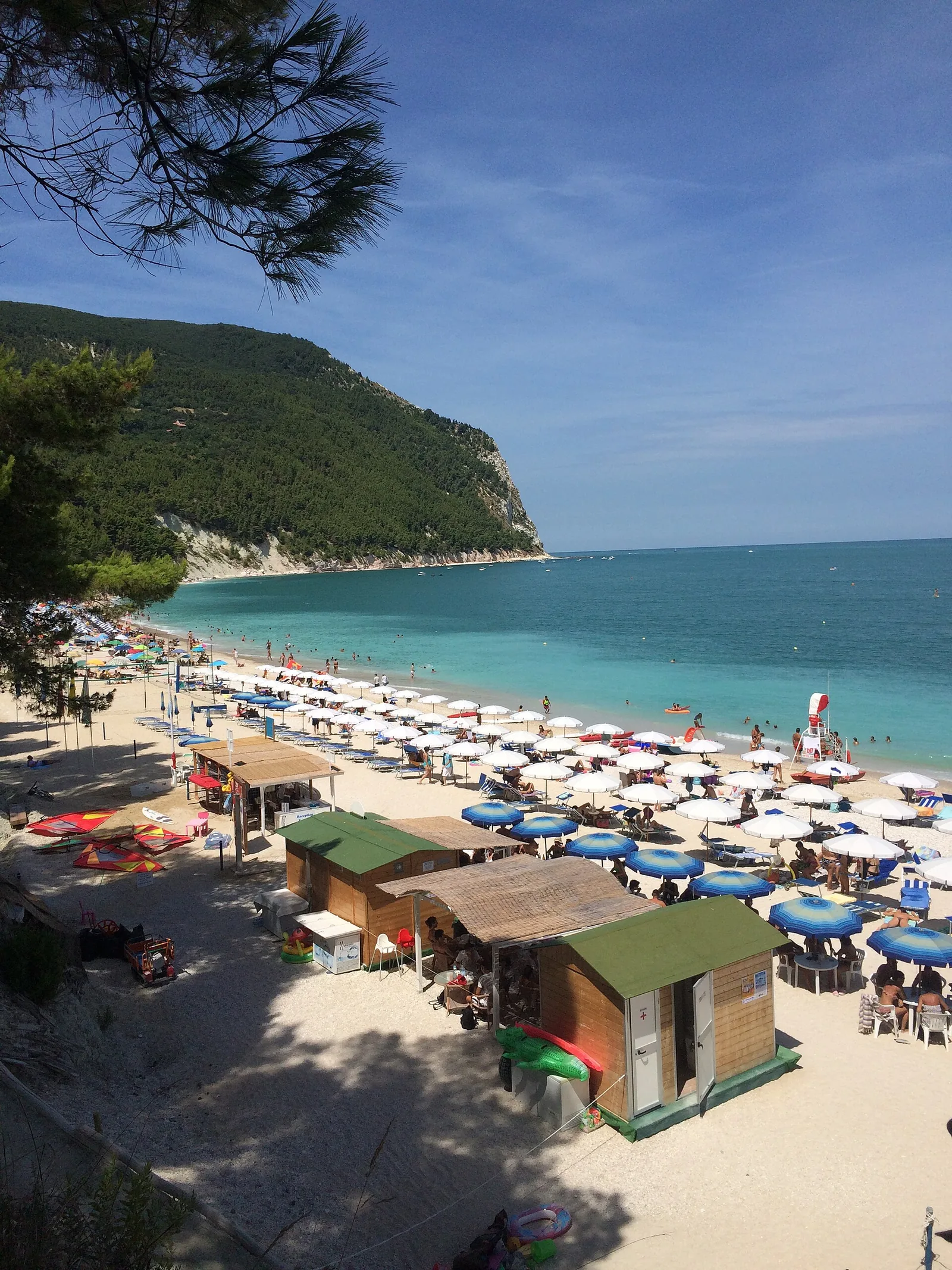
San Michele beach is in the municipality of Sirolo, at the foot of the Conero cliff: the Conero Park authority studies it together with the Sassi Neri as a single beach, San Michele–Sassi Neri. It is a pebble beach facing the Adriatic. The village of Sirolo lies 0.4 km to the south-west as the crow flies.
Under the park plan the beach lies in a 'riserva orientata' (managed reserve) zone; it is also part of the Natura 2000 network, within the Monte Conero SPA and SCI sites. In its 2016 report the Park authority notes its inestimable environmental value and very rare landscape value, but also, among the critical issues, excessive tourist pressure during the bathing season.
The shoreline changes with winter and spring storms: depending on the prevailing currents, the beach is wider in its northern or in its southern part. Satellite images show a wide beach in the northern part in 2013 and a wider beach in the south in 2016. In the Park authority's survey the total area was 31,290 square metres in 2013 and 28,956 in 2016.
Getting there
Trail 304 of the Conero park, Spiaggia di San Michele, is classed as a tourist trail: it is 1.8 km long and takes about 1 hour. It starts from Sirolo town hall, near the roundabout, and follows via Piave to the viewpoint over Monte Conero and the Sassi Neri beach. From there the path crosses a wood of Aleppo pines and descends quickly to the beach.
In its 2016 monitoring the Park authority found that the unpaved road leading from the Parco della Repubblica, in the centre of Sirolo, to the start of the beach is used mainly on foot, except for vehicles authorised by the municipality for the Da Marco establishment. The paved road of via Saletto was closed to general traffic by an automatic gate that could only be opened by remote control.
In 2026 the Comune di Sirolo published the timetables of the service to the San Michele–Sassi Neri beach for July and August, as well as a combined timetable from 30 May to 30 June and from 1 September to 27 September. Before setting off, it is worth checking the updated timetables on the municipality's website.
When to go
In its 2016 survey the Park authority observed that in high season, on Sundays, for much of August and, with fewer people, on Saturdays the beach clubs' umbrellas were fully taken and on the free beaches only room to move around was left. The satellite photo of Sunday 4 August 2013 shows 573 umbrellas in the beach clubs and at least 170 on the southernmost free beach.
Judging by the orientation of the coast, the beach faces east. It is exposed to the north-easterly (grecale), the easterly (levante) and the south-easterly (scirocco), which blow in from the sea; it is sheltered from the south-westerly (libeccio), the westerly (ponente) and the north-westerly (maestrale), which blow from the land. The northerly (tramontana) and the southerly (ostro) strike it side-on. This is an indication based on orientation, not a forecast.
Seabed and sea
In the 2025 season the European Environment Agency rated the bathing water quality as excellent. The activities planned under the management plan for the Natura 2000 sites include monitoring of the Pinna nobilis populations, of macroalgae and of the benthic communities of the seabed.
On 4 March 2026 the members of the regional executive responsible for coastal defence and economic development carried out an inspection to assess the damage to the shore and to the cliff above the beach after recent violent storms. According to the municipality, the storms completely wiped out the stretch of shore linking San Michele–Sassi Neri to Urbani beach, compromising the only escape route for visitors. Significant landslides have occurred along the cliff, which has retreated by about 21 metres over the last 23 years.
Facilities and free beach
In 2016 the beach alternated free stretches and stretches run under concession. The Park authority then counted four beach clubs there, Da Marco, Silvio Sud, Da Roberto and Silvio, with concessions of about 20-21 metres by 100-120. After a violent storm that had narrowed the beach, the owners of the Silvio beach club said they had removed 80 umbrellas. In 2016 the free stretches lay in the north, between one beach club and the next, and in the south.
Rules and protected areas
From the usable area the Park authority excludes the 5-metre strip along the shoreline, reserved by law, and a strip about 10 metres wide along the edge of the cliff, to protect habitats; some free stretches were also excluded under an ordinance relating to landslides. The management plan's measures include the obligation to use only the trails designated by the Park authority and the regulation of access to the most sensitive coastal areas.
In its 2016 monitoring of trail 303 to the Sassi Neri the Park authority recorded only pedestrians. The Conero park reports that trails 302 and 313 are closed on the sections leading down to the sea and that a mayoral ordinance prohibits reaching the Due Sorelle beach.
With children
Trail 304 descends quickly to the beach. With children it is best to wear suitable footwear and proceed with care. For young children it is useful to bring water shoes, shade and enough water.
Nearby
In 2026 Sirolo's Sassi Neri / San Michele / Urbani and Due Sorelle stretches appear on the list of Blue Flag beaches compiled by the FEE. Trail 303, 2.9 km long and about 45 minutes, starts from Sirolo town hall, climbs via Vallone to a viewpoint and descends through a pine wood and then Mediterranean scrub to the Sassi Neri, from where you can see the red 'scaglia' rocks of this stretch of coast.
The description of trail 304 says that from the beach you can continue to the Urbani cave, a cavity carved by the sea at the foot of the Sirolo cliff; in March 2026, however, the municipality reported that, after the recent storms, the stretch of shore towards Urbani beach had disappeared. Numana lies 1.9 km to the south as the crow flies. Hiking maps can be bought at the Park Visitor Centre in Sirolo, via Peschiera 30.
Sources
- Ente Parco del Conero — Spiaggia San Michele / Sassi Neri, monitoraggio e carrying capacity (2016)
- Regione Marche — Sirolo, sopralluogo per interventi urgenti di difesa della costa e della falesia (4 marzo 2026)
- QualeSpiaggia — open data spiagge (CC BY 4.0)
- OpenStreetMap
- Parco del Conero — Tutti i sentieri del Parco
- Comune di Sirolo — Orari collegamento alle spiagge, stagione estiva 2026
- EEA — Bathing water quality 2025 (IT011042048004)
- FEE Italia — Bandiera Blu 2026, elenco spiagge