
 40.226° N, 9.626° E


Complete guide
Cala Luna: beach guide
What the beach is like
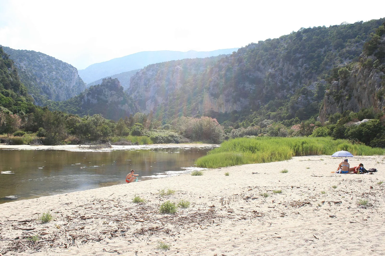
Cala Luna is an inlet in the Gulf of Orosei, on the central-eastern coast of Sardinia; in the QualeSpiaggia dataset it is assigned to the municipality of Dorgali. The inlet is carved into the cliffs and has at its centre an 800-metre strip of very fine golden sand. The cove lies at the mouth of the rio Illune, a stream that over thousands of years has cut a long canyon, the codula di Luna. Water flows down the gorge for kilometres and feeds a small lake behind the beach, fringed by a grove of oleanders and Mediterranean scrub. The river mouth marks the boundary between the territories of Baunei, in Ogliastra, and Dorgali, in the Barbagia di Nuoro, two municipalities that share the pride of the cove.
The cove is protected by steep rock walls dropping sheer into the sea, 300 metres high and bolted in places, a magnet for many climbers. On one side it is framed by punta su Masongiu, on the other the cliffs open into five large caves. The official tourism portal of the Sardinia Region calls it a symbol of eastern Sardinia and one of the wonders of the Gulf of Orosei.
According to Baunei's official tourism website, local people see the name Cala Luna as a corruption of the Sardinian place name, which sounds like Elùne in Baunei and Ilùne in Dorgali. The change is said to be due to Piedmontese geographers who arrived in the nineteenth century to update the maps of the kingdom. The regional portal recalls that the name Elune was used by shepherds who came on foot from Baunei, an eight-hour walk. In 1974 Lina Wertmuller made it the setting of Travolti da un insolito destino nell'azzurro mare d'agosto, starring Mariangela Melato and Giancarlo Giannini. The cove was also the backdrop for the 2002 remake Swept Away, with Madonna, and for Il signor Robinson in 1976, with Paolo Villaggio.
Getting there
The easiest way is by sea, with private boats, hired rubber dinghies or boats leaving from the ports of Arbatax, Santa Maria Navarrese and Cala Gonone. Cala Gonone, the nearest port, lies 6.3 km north of the beach as the crow flies.
On foot you can start from Cala Fuili, which can be reached by car or bike from the village of Cala Gonone. The route takes an hour and a half, with ups and downs along the coast. An alternative for the fittest starts at km 172 of state road 125: ten kilometres by car along a narrow road to Telettotes and from there another ten on foot along the codula di Luna. A third option is the dirt track that starts near monte Malopès: eight kilometres by car, then a steep path down to the codula, two kilometres from the beach. Suitable shoes and enough water are needed for the paths.
When to go
Judging by the orientation of the coast, the beach faces east. According to QualeSpiaggia data it is exposed to the north-east wind (grecale), the east wind (levante) and the south-east wind (scirocco), which come in from the sea, while it is sheltered from the south-west wind (libeccio), the west wind (ponente) and the north-west wind (maestrale), which blow from the land. This is an indication derived from the orientation, not a forecast. Anyone arriving by boat would do well to check sea conditions before setting off.
In the caves you can enjoy shade in the hottest hours and see the sea enclosed as if in a flask.
Seabed and sea
The seabed is shallow for the first few metres and then quickly becomes deep. It is popular with people who go snorkelling, diving and spearfishing. The sea is clear, with blue tones. The beach looks out over the Tyrrhenian Sea. In the 2025 season the European Environment Agency rated the bathing water quality as excellent.
Facilities and free beach
In the grove behind the small lake there is a kiosk and a bar-restaurant. According to Baunei's tourism website, a tavern opened in 1978 stands on the ruins of the charcoal burners' storeroom and is called Su Neulagi, meaning the oleander in Sardinian, in homage to the grove in front of the small lake.
In a clarification dated 31.08.2021 on the procedure for a six-year concession of the cove's jetty, intended for mooring and for landing passengers, the Region recalled the obligation to make it safe. The tender also provided for boardwalks and facilities to make it easier for people with disabilities to reach the beach.
Rules and protected areas
In Sardinia, regional law no. 16 of 2017 sets a fine of 500 to 3,000 euros for anyone who removes, keeps or sells even small quantities of sand, pebbles, stones or shells from the coast without authorisation. Before setting off it is worth checking with both municipalities the landing and entry rules in force.
Nearby
Along the cliffs between the cove and Cala Gonone there are cavities that are part of a vast karst system. The best known are the grotte del Bue Marino, with stalactites, stalagmites, small lakes and little beaches, once a habitat of the monk seal. Their entrances are three kilometres from Cala Luna.
5.2 km south as the crow flies, in the territory of Baunei, lies Cala Sisine, a small bay between cliffs 500 metres high at the end of a codula that can be walked on a long trek. Further south, in the same gulf, Cala Mariolu is known for its round pebbles mixed with sand and can only be reached on foot by a trek for experienced hikers.
Sources
- Cala Luna | SardegnaTurismo - Sito ufficiale del turismo della Regione Sardegna
- QualeSpiaggia — open data spiagge (CC BY 4.0)
- Turismo Baunei (sito ufficiale) — Cala Luna
- OpenStreetMap
- EEA — Bathing water quality 2025 (IT020091017007)
- Regione Sardegna, Servizio demanio di Nuoro — Concessione del pontile di Cala Luna, chiarimento n. 2 (2021)
- Agenzia delle Dogane e dei Monopoli — Comunicato stampa Sardegna, 6 agosto 2024